MAKING SCIENCE AVAILABLE
We believe that I•GIS exists to make state-of-the-art geoscientific research available to geoscientific practitioners.
TRANSPARENT SOLUTIONS
At I•GIS, we prioritize transparency in our solutions, ensuring they are user-friendly and accessible. We value open-source principles and our work is grounded in peer-reviewed methodologies.
DEVELOPMENT THROUGH RESEARCH
Over the past decade, I•GIS has been actively involved in numerous national and international research and development projects. Our collaborations extend to leading universities and research organizations, as well as end-users, with the goal of developing and delivering state-of-the-art geoscientific solutions.
This ensures our current and future users always have access to the latest advancements. Below, you'll find detailed information about our ongoing and past projects, along with insights into the specific tools, services, and software solutions that have emerged from these collaborations.
PROJECTS
INTEGRATE – Informative Mapping of Construction Aggregate Resources Through Statistical Data Analysis
Construction aggregates is a broad category of coarse-grained materials like sand, gravel and stone used in construction and infrastructure projects.
Aggregates are the most mined resources globally, and annually about 25 million cubic meters are extracted and processed in Denmark. A significant part of the aggregate costs is related to transportation. In Denmark, the direct costs amount to approx. 3 billion DKK annually.
Calculations suggest that an additional 650M DKK are needed to cover indirect costs related to abrasion of roads, accidents, climate change, air pollution, congestion, etc.
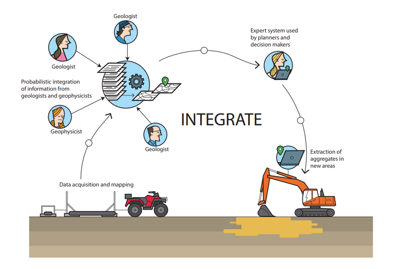
Therefore, this project’s vision is to build a new and beyond state-of-the-art framework, based on information theory, allowing more informative mapping of aggregate resources using electromagnetic (EM) measurements. On top of the mapping framework, we will develop a web-based frontend system, allowing decision makers to extract relevant information to perform aggregate resource extraction planning.
With this framework it will be possible to locate new aggregate resources, and in turn save millions in reduced transportation costs.
The project aims to revolutionize mapping of the near surface, using EM data, and the outcome will have a significant economic, societal, and environmental impact. In addition, it will strengthen Denmark’s position as an international frontrunner on utilizing EM data in subsurface mapping, and provide new export opportunities for Danish technology.
For more information visit the Innovation Fund Denmark website or contact us at consultancy@geoscene3d.com

Reduction and Documentation of CO2 emissions from Peatlands
Depending on their present condition, peatlands can store a huge amount of carbon (C) or be a source of carbon dioxide (CO2), which is a crucial challenge globally.
In Denmark, peatlands constitute a key target to achieve the national goal of reducing CO2 emissions with 70% by 2030. There is thus a great need to investigate the spatial variability of peat soil properties in order to assess the total amount of C stored in these soils.
Through the combination of state of-the-art hardware, software, modelling techniques and IT technologies the present project will develop an overall methodology to map peatlands in detail and enable accurate estimates of CO2 emissions and potential C stocks.
This methodology will provide decision-makers with detailed information and cost-effective tools to appropriately select which peatland areas to take out of agricultural production and restore. Notably, the combination of the drone-mounted cutting-edge geophysical sensors, advanced 2D modelling techniques and 3D software will be a game changer for peatland mapping both nationally and worldwide.
The project started in the fall of 2020 and runs for four years. The total project budget is DKK 32.3 million where DKK 24.3 million is funded by the Innovation Fund Denmark. The project consortium covers representatives from the Department of Agroecology at Aarhus University, Aalborg University, Region Midtjylland, SkyTEM, and I∙GIS.
For more information visit the project homepage or contact us at consultancy@geoscene3d.com

GAP - Groundwater Architecture Project
In an ambitious two-year project, Stanford University partners with leading Danish companies and three water agencies in California to develop a template for an optimal workflow that would use airborne electromagnetic (AEM) data as the foundation for the development of hydrogeological conceptual models.
This provides a key step in the implementation of the Sustainable Groundwater Management Act (SGMA) in California and will provide value to groundwater architecture mapping worldwide.
The workflow includes not only the deployment of the AEM technology to acquire vast amounts of AEM data, but more importantly designing the supporting geophysical and computational infrastructure for data analysis, interpretation, and archiving.
Significant advancements can be made by studying ways in which California can develop and implement a workflow and build on Danish experience.
The Project is partly financed by The Danish Eco-Innovation Program (MUDP) and partly by the state of California and is a 2 year project running from September 2018 including Stanford Univeristy, Aarhus University, Aqua Geo Framework, Rambøll, and I•GIS.
For more information contact us at consultancy@geoscene3d.com
Probabilistic Geomodeling of Groundwater Resources
Groundwater mapping in Denmark is internationally acknowledged and regarded as a benchmark approach. Huge amounts of data (well logs, geophysical, geo- and hydro-logical data) have been collected.
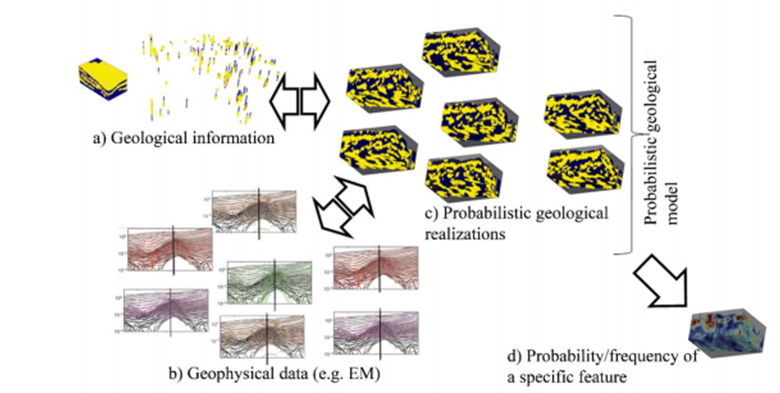
Today these data are combined in a deterministic sequential workflow, where, typically, a single final model represents all available information. While successful, this workflow has some limitations: There is no way to ensure the final model consistency with all information at hand, and there is no way to ensure correct uncertainty quantification.
To remedy this, we propose to develop a probabilistic data integration workflow that allows consistent integration of well-log, geophysical and geological data. The results will be a probabilistic geological model that: a) will be consistent with all data, and b) allow detailed uncertainty analysis. The resulting probabilistic geo-model can be efficiently used by the end-users for informed, data-driven, decision- making and for risk assessment.
The Project is partly financed by The Independent Research Fund Denmark and is a 3 year project running from May 2018 including University of Copenhagen, Aarhus University, United States Geological Survey (USGS), University of Cagliari, and I•GIS.
For more information visit the project homepage or contact us at consultancy@geoscene3d.com

Mapping Geology in Cities
Based on the increasing urbanization, building activity, contamination, and drainage of climate change induced heavy precipitation, a need for knowledge about the urban subsurface in modern cities is growing fast.
To obtain this knowledge, a massive amount of geotechnical data, and tools to obtain, visualize and interpret on these data are required. This project deal with these challenges, and aim to develop integrated tools enabling non-geoscience experts to both generate and and utilize urban geothechnical information.
To achieve this, the MAGIC project aim at delivering:
- Geophysical Instruments adapted to the urban environment
- Virtually 100% automated data processing and inversion software
- High-Resolution 3D geological modeling software incorporating city infrastructure and geophysical inversion results
- Unified and seamless data workflow
The Project is partly financed by EUROSTARS and is a 2 year project running from April 2016 including Lund Technical Univeristy, Guideline Geo AB, Aarhus University, and I•GIS.
For more information contact us at consultancy@geoscene3d.com
Probabilistic Geomodeling of Groundwater Resources
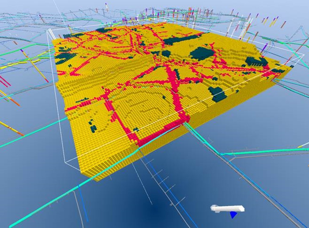
This project intend to develop a foundation for geological modeling in cities. By developing tools and workflows for urban geological modeling the hope is to enable the cities to utilize the geological potential with respect to more sustainability concerning water supply, climate adaption, and heat storage.
To achieve this, the project has two main scientific goals:
- Improve management, design, and construction of urban subsurface infrastructure through new methods of urban geological mapping by activating and including non-digitized geological archive data.
- Enable High Definition 3D visualization allowing easier and better utilization of the geological information and the different geo-data.
The Project is partly financed by the Danish Eco-Innovation Program (MUDP) and is a 2 year project running from January 2016 including GEO, University of Copenhagen, Frederiksberg Forsyning and I•GIS
For more information contact us at consultancy@geoscene3d.com

Effective High Resolution Geological Modelling
The goal of this project is to develop a user-friendly expert system that can combine a vast amount of different geo-data with geological expert knowledge.
One part of the system will utilize machine learning approaches developed through the research project enabling fast and accurate geological interpretations.
The other part will be based on the development of the theory of Multiple Point Statistics (MPS) to allow correctly integration of soft (uncertain) data in the MPS simulations.
The project is partly financed by the Danish National Advanced Technology Foundation and is a 3-year project running from November 2013 including The Geological Survey of Denmark and Greenland, University of Copenhagen and I•GIS.
For more information contact us at consultancy@geoscene3d.com
R&D RESULTS

Simulation Extension
In the Simulation Extension , GeoScene3D utilizes and extends a new implementation of MPS algorithms developed in cooperation between I•GIS and researchers at the Niels-Bohr Institute, University of Copenhagen and the Danish Geological Survey (GEUS), as part of the Danish geological modeling research project, ERGO.
MPS provides a statistical approach to modeling the geological heterogeneity observed within rock type variations. It is an alternative to Gaussian-based geostatistics with semi-variograms, and instead relies on geological knowledge captured in user-defined Training Images. For a theoretical overview of the MPS version implemented in GeoScene3D and the theoretical innovations made on this field through the ERGO project see: Hansen et al. 2016, Hansen et al. 2018 and Høyer et al. 2017.
The Simulation Extension adds extra functionality to the Voxel Builder Module in GeoScene3D, giving access to Multiple Point Statistics for property simulation in voxel models. These tools provide you with the functionality for working with the latest advancements in geological modeling, all wrapped up in a sequence of user friendly software Wizards, guiding you through the modeling workflow.
For more information contact us at consultancy@geoscene3d.com
Smart Interpretation
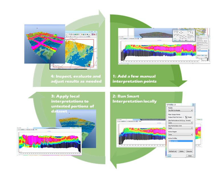
Smart Interpretation (SI) is a tool for fast and accurate geological layer modeling developed together with the University of Copenhagen as part of the ERGO project.
SI is a clever implicit modeling approach based on machine learning allowing the computer to learn what the geologist do when (s)he interprets geological layers based on airborne electromagnetic (AEM) data.
Based on what the machine has learned from the geologist's interpretations the tool will predict how the geologist would interpret throughout the rest of the survey. This way, the SI algorithm will help speed up the interpretation process and at the same time include all available data and the expert knowledge from the geologist training the system. For a theoretical summary of the method see: Gulbrandsen et al. 2015, 2017a.
The Smart Interpretation tool is included in the AEM extension , and has proven to be very successful through a number of applications. See e.g. Gulbrandsen et al. 2016, Anschuetz et al. 2016, Gulbrandsen et al. 2017b, Munday et al. 2018, Gulbrandsen et al. 2018
For more information contact us at consultancy@geoscene3d.com
Voxel Modeling
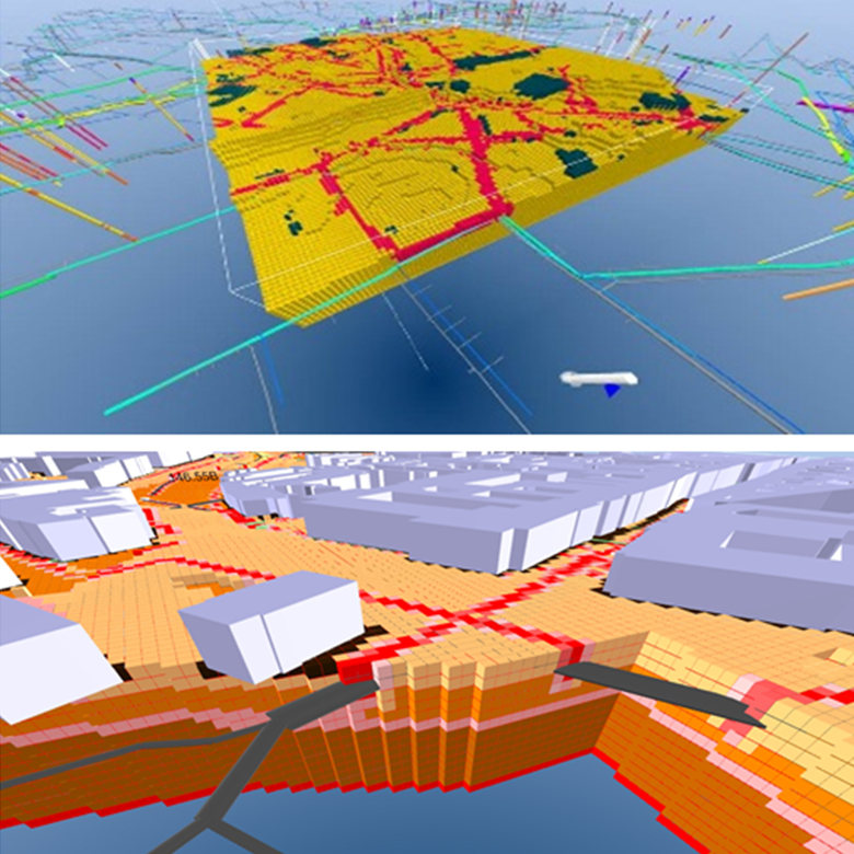
The Voxel Builder is a specialized add-on module for building voxel models in GeoScene3D developed in the Geosmart Cities project.
The module is initially developed to handle urban geological modelling and other modeling jobs requiring high resolution geological models. This makes the module well suited to handle tasks involving compilation and interpretation or visualization of a variety of data types.
The module includes a series of tools allowing an easy workflow for model setup and editing as well as tools to simplify inclusion of infrastructure features such as pipelines, roads, buildings, etc. to the geological model.
Only the imagination puts a restriction on the possible applications using the Voxel Builder module. However, among some of the geological modelling applications carried out by our users are:
- Smart city development
- Engineering geology
- Groundwater Management
- Soil Contamination
- Surface near water flow in the field of WSUD
- Future climate assessments
For more information contact us at consultancy@geoscene3d.com
THEORETICAL
MATERIALS
Publications and Proceedings
Smart interpretation
Smart Interpretation - automatic geological interpretations based on supervised statistical models, 2017
Automatic mapping of the base of aquifer - A case study from Morrill, Nebraska, 2017
Localized smart interpretation - a data driven semi-automatic geological modeling method, 2015
Multiple Point statistics (MPS)
A Workflow Allowing Multiple Point Statistics Realizations to Reveal where we Lack Information, 2019
Multiple point statistical simulation using uncertain (soft) conditional data, 2018
Multiple-point statistical simulation for hydrogeological models: 3-D training image development and conditioning strategies, 2017
A C++ class for sequantial simulation of multiple-point statistical models, 2016
CASE STUDIES
Publications and Proceedings
Smart interpretation
Peeling back the cover on an ancient landscape – AEM in the Musgrave Province, 2018
A 3D geological soil-modelling workflow using AEM data – A case study from Gotland, Sweden, 2018
Automatic Mapping of Permafrost in the Yukon Flats, 2016
Multiple Point statistics (MPS)
Multiple-point statistical modeling of three-dimensional glacial aquifer heterogeneity for improved groundwater management
Using Multiple Point Statistics in Indian Wells Valley, California to estimate aquifer storage capacity
Geological modeling
A 3D geological model of the Island of Gotland based on extensive airborne EM mapping, seismic data and log stratigraphy, 2018
Improved geological information by modelling airborne TEM data over the island of Öland, Sweden, 2018
Reports
Revealing multiple geological scenarios through unsupervised clustering of realizations from the posterior distribution, 2016
Posters and Presentations
3D hydrogeological conceptual model building in Denmark Open Document
Detailed Geological Modeling In Urban Areas. Datatypes, tools and workflow. An example from Denmark Open Document
OUR R&D PARTNERS
As we strongly believe in the importance of a knowledge-driven approach when improving our products and services, we always aim at collaborating with renowned researchers from top universities and research institutions.
Therefore we are proud to present this list of collaborating research partners:


